
Image
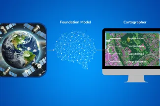
A collaboration between GEODETICCA VISION and Slovakia’s national HPC centre demonstrates how supercomputing can help SMEs develop advanced AI solutions, reduce costs and expand into new markets.
The Challenge
Satellite and aerial imagery provide valuable information for urban planning, environmental monitoring, infrastructure management and emergency response. However, converting vast amounts of imagery into accurate, usable geographic data remains computationally demanding.
Slovak company GEODETICCA VISION develops CARTOGRAPHER, an AI-powered platform that transforms satellite and aerial imagery into vector data.
One of the company's main challenges was adapting AI models to different European regions. Traditional approaches required extensive manually annotated training datasets, making deployment expensive and time-consuming.
To scale its technology across Europe, GEODETICCA VISION needed an AI model capable of understanding diverse geographic environments while requiring significantly less labelled data.
Developing such a model required processing enormous volumes of imagery and accessing computing resources beyond those typically available to a small or medium-sized enterprise.
The HPC Solution
GEODETICCA VISION collaborated with the Centre of Shared Activities of the Slovak Academy of Sciences, Slovakia's national HPC centre, through the European FFplus programme.
The collaboration combined the company's expertise in geospatial AI with the HPC centre's knowledge of large-scale data processing, parallel computing and AI workflows.
Two European supercomputing systems contributed to the project:
- Devana, Slovakia's national supercomputer, supported large-scale data preparation.
- MareNostrum 5, hosted at the Barcelona Supercomputing Center, was used to train the foundation model.
Using HPC resources, the project team processed approximately 90 TB of raw imagery covering 17 European countries.
The data was transformed into a curated training dataset of approximately 9 TB containing 600 million samples.
This enabled the development of the GEODETICCA VISION Foundation Model (GVFM), designed to support geospatial AI applications across different European landscapes.
Following training, the model was fine-tuned using GEODETICCA VISION's segmentation data and integrated into its CARTOGRAPHER platform.
Results and Measurable Benefits
The project demonstrated substantial improvements in the efficiency and scalability of geospatial AI.
87.5% reduction in labelled data requirements
The new approach significantly reduced the amount of manually annotated data needed to adapt the model to new applications.
33% higher accuracy
The foundation model achieved a 33% improvement in accuracy compared with previous models on the company's proprietary land-use data.
Lower project costs
For a typical dataset, estimated project costs decreased from approximately €170,000 to €25,500, representing a reduction of €144,500.
Scalability across European regions
A reusable foundation model supports applications in different geographic environments without requiring complete retraining for each region.
These improvements help GEODETICCA VISION deploy solutions faster and offer more affordable services to customers across Europe.
Business and Societal Impact
The project demonstrates how access to HPC infrastructure can help European SMEs overcome technological barriers and compete in advanced AI markets.
For GEODETICCA VISION, the foundation model creates opportunities to expand the CARTOGRAPHER platform into new geographic markets and serve organisations with limited budgets.
Potential applications include:
- Urban and land-use planning
- Environmental monitoring
- Infrastructure mapping
- Emergency and disaster-response mapping
- Geospatial data services for public authorities
By reducing the costs of preparing training datasets and deploying AI models, the solution can make advanced geospatial analysis more accessible to local governments, environmental organisations and smaller businesses.
The Role of the Slovak HPC Centre
The Centre of Shared Activities of the Slovak Academy of Sciences contributed technical expertise in high-performance computing, parallel programming, data processing and AI workflows.
The Devana supercomputer supported the preparation of large-scale datasets, while the European HPC ecosystem provided the additional resources required for model training.
This collaboration illustrates how national HPC expertise and European supercomputing infrastructure can work together to support innovation and technology adoption in industry.
Project Information
Project: Foundation Model for European Geospatial Mapping
Programme: FFplus – Innovation Studies
Country: Slovakia
Industrial partner: GEODETICCA VISION s.r.o.
HPC partner: Centre of Shared Activities of the Slovak Academy of Sciences
HPC systems: Devana and MareNostrum 5
Application area: Artificial intelligence, geospatial analysis, satellite and aerial imagery processing
Project period: February – November 2025
Sources
FFplus Success Story:
https://www.ffplus-project.eu/en/success-stories/foundation-model-for-european-geospatial-mapping/
Slovak HPC Centre:
https://hpc.sav.sk/slovenske-hpc-centrum-pomaha-firmam-skalovat-ai-riesenia-pre-europu/
Funding acknowledgement: The project was supported through FFplus, funded by the European High Performance Computing Joint Undertaking under grant agreement No. 101163317, with support from the Digital Europe Programme.