Image

NCC Bulgaria presents the success story
NCC Bulgaria has been founded by the Institute of Information and Communication Technologies at the Bulgarian Academy of Sciences, Sofia University “St. Kliment Ohridski”, and the University of National and World Economy. NCC Bulgaria is focused on:
Creating a roadmap for successful work in the field of HPC, big data analysis, and AI,
Analyzing the existing competencies and facilitating the use of HPC/HPDA/AI in Bulgaria
Raising awareness and promoting HPC/HPDA/AI use in companies and the public sector.
Scientific partners involved:
 Svilengrad Municipality is situated in south-eastern Bulgaria at the tri-border area between Bulgaria, Greece, and Turkey. This zone has experienced an increased frequency and intensity of natural hazards over the past decade, with wildland fires and torrential floods representing the most significant threats. These conditions have intensified the municipality’s collaboration with the Department of Modelling and Optimization at the Institute of Information and Communication Technologies, Bulgarian Academy of Sciences, under the leadership of Prof. Dr. Nina Dobrinkova.
The municipal involvement in the scientific-public collaboration was under the governance of Deputy Mayor Svetlana Dinkova, responsible for disaster prevention and preparedness in Svilengrad Municipality, and Chief Inspector Ivelin Tonev, Director of the Svilengrad Firefighting and Civil Protection Directorate of the Bulgarian Ministry of Interior. Their engagement ensures that the scientific outputs of the projects are aligned with operational needs and can be effectively integrated into local and cross-border civil protection practices.
Technical/scientific Challenge:
Svilengrad Municipality is exposed to two primary natural hazards: torrential floods, driven by the dense Maritsa River watershed, and recurring wildland fires. The increasing frequency and severity of these hazards in recent years have created a complex operational environment, requiring enhanced situational awareness, cross-border coordination, and scientifically supported decision-making. The major scientific challenges for wildfire and torrential floods technical solutions development can be structured as:
Wildland Fires – These occur every year due to favorable weather conditions, large depopulated zones, and poorly managed land. Fires can spread quickly, and if flames cross the Maritsa River, they pose a direct threat to the neighboring Orestiada Municipality in Greece.
Torrential Floods – Generated by the dense watershed of the Maritsa River, torrential floods require continuous monitoring to prevent damage to communities and critical infrastructure in the cross-border zone of Bulgaria, Greece, and Turkey.
Despite the Svilengrad municipality's preparedness efforts, several key technical gaps were identified:
Meteorological and hydrological data were often delayed or incomplete, making rapid response difficult.
Geospatial information (roads, forests, water networks, critical infrastructure) was fragmented across different sources, preventing a unified view of risk.
Scientific modeling of hazards was not fully integrated into decision-making, limiting proactive planning.
Cross-border coordination with Greek and Turkish authorities was limited, risking delayed or uncoordinated action.
Communication among municipal authorities, firefighting units, and volunteers from the three countries was not fully synchronized during emergencies.
Solution thanks to the collaboration:
The team of Prof. Dr. Nina Dobrinkova, as part of the Institute of Information and Communication Technologies, Bulgarian Academy of Sciences, has maintained long-term collaboration with Svilengrad Municipality since 2012. This collaboration has been reinforced through participation in four common cross-border projects:
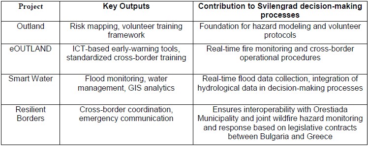
Outland – focusing on initial frameworks for risk mapping and civil-protection volunteer training.
eOUTLAND (Interreg Greece–Bulgaria) – providing standardized cross-border training, ICT-based early-warning tools, and fire-risk assessment methodologies for protected areas.
Smart Water – enhancing flood monitoring and water management using real-time sensors and GIS-based analytics.
Resilient Borders (Cross-Border Spatial Planning and Crisis Management Pilot Actions Programme) – improving operational interoperability, emergency communication, and coordinated cross-border response between Svilengrad and Orestiada Municipalities.
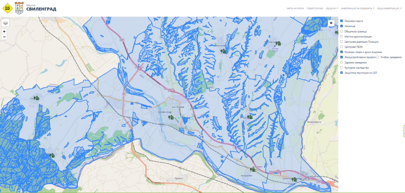
Together, these projects provide a robust scientific and operational foundation for integrated hazard management in the region framed in the open source solution called – https://riskmap.bg/. The tool is a web-based GIS platform implemented in Svilengrad Municipality as a pilot zone, providing information about:
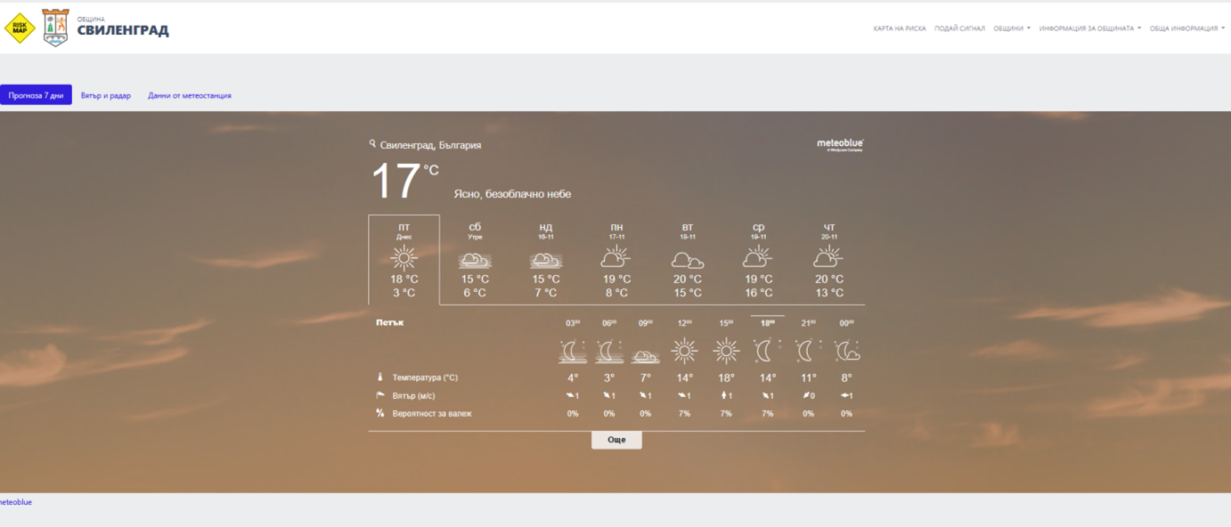
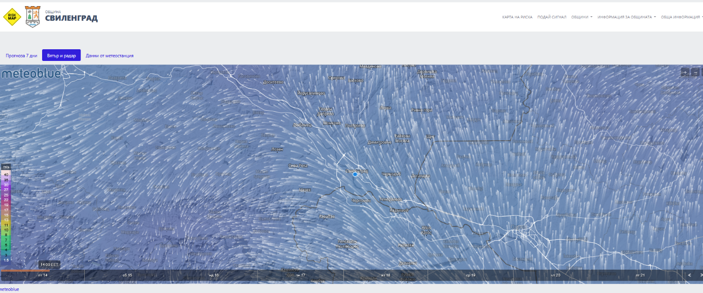
Meteorological integration: The platform combines free open-data sources with a dedicated local meteorological station, providing near real-time monitoring of temperature, wind speed, wind direction, and precipitation.
Unified geospatial visualization: Authorities can access layers for forestry, roads, water bodies, and critical infrastructure, enabling rapid operational decision-making.
Cross-project synergy: The platform riskmap.bg integrates methodologies and data inputs developed in Outland, eOUTLAND, and Smart Water, providing a consolidated tool for both wildfire and flood management.
The developed tool and implemented projects strengthened the local and cross-border response capacity of the zone. The integration of GIS and real-time environmental data has improved coordination between the municipal authorities, local firefighting units, volunteer groups, and cross-border partners. The combined operational knowledge from the Resilient Borders project ensured that the future interventions are interoperable and aligned with Bulgarian-Greek cross-border protocols.
Benefits:
Faster Operational Response: The use of High Performance Computing (HPC) enables enhanced modelling of wildfire behaviour and flood dynamics, facilitating quicker and more accurate simulations that municipalities can rely on during emergencies.
Enhanced Situational Awareness: By accelerating the processing of meteorological, hydrological, and GIS data, HPC assists platforms like riskmap.bg in delivering real-time, high-resolution forecasts that support faster and more coordinated decision-making.
Cross-Border Coordination: Standardised protocols reduce delays in communication and joint actions between Svilengrad and Orestiada Municipalities.
Data-Driven Decision Making: GIS data and near-real-time meteorological conditions aid in the deployment of resources, evacuation plans, and preventive measures.
Success story :
Keywords: GIS, meteo data, web-based decision support systems
Research areas: Web-GIS, wildfires, torrential floods, meteorology
Technology: Big data analysis in the decision-making process
Highlights:
Effective cross-border risk mitigation through combined project outputs.
Validation of multi-project synergy (Outland, eOUTLAND, Smart Water, Resilient Borders).
Contact:
- Nina Dobrinkova, dobrinkova (at) iict.bas.bg, Valko Stoykov, and Andriana Zlatkova, Institute of Information and Communication Technologies at the Bulgarian Academy of Sciences